Sunday, December 11, 2011

Design Proposal, December the 8th

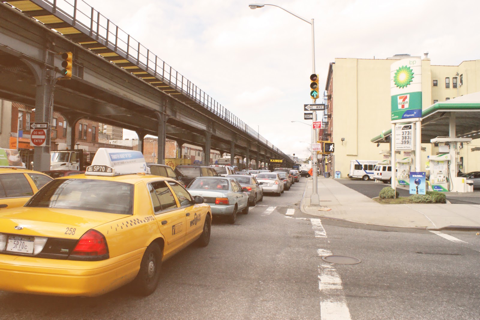
Running from the western waterfront of Brooklyn, at the Brooklyn Bridge Park, to the Van Wyck Expy in Queens, the Atlantic Avenue is a total of 16,5 kilometers long. Of these very divers 16,5 km, there is a notable different part of approximately three kilometers located in the neighborhood of Crown Heights, in between Bedford Avenue and Dewy Place. It varies from the other parts due to the elevation of the Long Island Rail Road (LIRR). That elevation creates a strengthening of the one-way, longitudinal direction of the Atlantic Avenue, mostly surounded by industrial/manufacturing buildings. The first element that created that longitudinal direction is the intense usage of the avenue by cars. Because of the high regularity of the columns of the above ground construction, there is also a wall created, which makes it more difficult to get a good look at the other side of the Atlantic Avenue. And again the longitudinal direction of the street is amplified by the monotonous use of the covered strip, under de LIRR. The only time when it's interrupted is when pedestrians cross the Atlantic Avenue, a use of a slower speed. They cross the street to get from their homes, in the residential area south of the Atlantic Avenue, to Fulton Street, a commercial axis with multiple subway stops. This link between these different important streets is fascinating because it is frequently used, but visual not distinct in the built environment.This connection is blocked by the closeness of the Atlantic Avenue and its facades. Those facades serve also as a soundbarrier against the LIRR, to the residential areas in Crown Heights south of the Atlantic Avenue and Bed-Stuy north of it. In between these two very strongly profiles axes is a residential zone, most of the time only half as wide as a normal building block and often mixed with other functions like public facilities.

By working on an urban scale I would want to propose to reveal this link between the Atlantic Avenue and Fulton Street. This by redefining the zone formed by those two,  parallel streets and also the south side of the Atlantic Avenue. And why not make this other, transverse direction visible for the longitudinal-users like the train passengers or the motorists. Those connections wil not weaken the primary functions of the axes, but will connect them. Ending in a short design exercise of an intersection of the Atlantic Avenue and a perpendicular street.
Why not make these links litteral visible?


A view on both streets, Fulton Street and Atlantic Avenue.

Quick Start Proposal, november 18th

Tuesday, December 6, 2011

What is the Atlantic Avenue?

From the western waterfront of Brooklyn, starting at the Brooklyn Bridge Park, to the Van Wyck Expy in Queens, the Atlantic Avenue is a total of 16,5 kilometers long. From this very divers 16,5 km there is a notable different part of approximately 3 kilometers, located in the neighborhood of Crown Heights.
It varies from the other parts due to the elevation of the Long Island Railroad.


Looking at the flows on the Atlantic Avenue, there is a differnce of direction and use. Pedestrians use it  differently than the automobiles does.
The elevated LIRR creates two very divers experiences of the facades of the Atlantic Avenue. One more directed at the big industry/manufacturing buildings. The other more at eye level.


How do you use the land around an elevated train? And especially the space under the LIRR. Which is now only used as a parking space, here and there.


A lot of the functions near the Atlantic Avenue can be seen as a barrier, a soundbarrier for the residential area against the train. Those functions are the industrial/manufacturing buildings but also the commercial, not mixed used, and public spaces. All of this is 73 percent of the two facades.

Answering the question 'What is the Atlantic Avenue?' isn't that simple. After a quick and short analysis it is clear that there is a very divers use of the street, but also of the area around the street with some similarities.


Wednesday, November 30, 2011

Crown Heights. Exploring the Grid


This presentation is about the site Crown Heights, and in this analysis, we are exploring the grid. During our analysis we have seen a potential to improve the livability of the grid. That’s why we asked ourselves some questions related to these topics.

Our first approach was to define the borders of Crown Heights, between which we collected all kinds of data. But after a while we came to the conclusion that neighborhoods that are located in the grid don't have specific borders. The aspects that form these borders can change in a very short period of time. That is why we changed our area of analysis to a larger area, including parts of adjacent neighborhoods such as East Flatbush, Brownsville, Prospect Heights and Bed-Stuy.

Presentation made by Antrees Engelen, Koen Moesen, Pieter Van den Poel, Arnout Van Soom, and Sofie Verjans.

Thursday, October 27, 2011

Case Study: The Atlantic Yards Project


INTRODUCTION
The Atlantic Yards Project in Brooklyn is a well-known project. Yet there are some uncertainties about who and what they are designing. One thing is certain, Forest City Ratner  is the developer. But who is the architect after the departure of Frank Gehry in 2009? How big is the actual project? What is its scale? When will it be finished? One can visually see the protest against it in Brooklyn, but who are the organizations behind the banners? Etc…

Source: Google Maps


Wednesday, October 26, 2011

Experiment on October the 8th, 2011

Experiencing and listening to the community feeling in Idalias Salon & iBeauty Bar, 677 Washington Avenue, Brooklyn.

Wednesday, October 19, 2011

Atlantic Avenue

Source: Google Streetview

Atlantic Avenue, Brooklyn, New York City –running from one waterfront to the other- is one of the most important routes in Brooklyn as it is the only East-West truck route throughout the borough. And not only in the present day does the avenue have importance, but also in the history of Brooklyn as the Atlantic Avenue Railroad.
It could be seen as an armature
(1)
, described as a linear system for sorting sub elements in the city and arranging them in sequence. This theory is suitable when one thinks about all the different neighborhoods linked to the Atlantic Avenue. It acts as a boundary between different communities a lot of the time.
Also very different places are pinned on the Atlantic, ranging from large projects such as the Atlantic Yards, to smaller antique shops, etc.
Does a ride on the Atlantic Avenue from East to West show striking social changes from one neighborhood to the other? Are the boundaries of the various neighborhoods noticeable? …
(1)    Shane, D.G. (2005) Recombinant Urbanism: Conceptual Modeling in Architecture, Urban Design and City Theory., Wiley

Presentation Collective Culture


How do people collectively express their culture? How do they color their surroundings?...
In order to find answers, we approached this matter through four types of public spaces –the community space, representative place, streetscape and the virtual realm- in which people demonstrate their collectiveness. We considered them as being equally important.


COMMUNITY SPACE

Community gardens require an engagement to be part of the collective culture, which distinguishes it from the general public space. It makes this community space by nature often exclusive. This exclusiveness could also be taken literally because of the fences around the gardens.
What is your influence as a designer? Can you allow the exclusiveness in terms of boundaries but design them differently so that they can be something more inviting?
Could you interfere in something which exists only of an informal group of people and doesn’t want a high end design? Or could you only be a gardener in the community space?


REPRESENTATIVE PLACE

We noticed a shift in representational space in terms of the big classical ideas to the contemporary.
Obviously, nowadays we don’t have institutions with that kind of power anymore and the representation of new public spaces has changed to the local and the temporal. Things that can be built up quickly and go away again. So what can a designer do to create new public spaces? Is it limited to small scale design such as painted public spaces and temporal installations as a container bar?


STREETSCAPE

There is a diverse and active urban culture in the streets of Brooklyn. Whether it is about expressing discontent with institutions, like a mural or poetry on a large facade, the built environment can serve as an art board for inhabitants. One could say that the streetscape also has the capacity to generate urban activity and invite people to interact with their environment.
Could this capability be more profound if a designer was asked to redesign Brooklyn’s streetscape?
Or do sidewalks and streets need to be designed like the great parkways that cross Brooklyn’s grid?


VIRTUAL REALM

The virtual realm is a relatively new public space which supports collective culture in general. People can join online communities, which reflects a feeling of belonging. The Internet is an easy way to reach out ideas to a large group of people and bring them together for a common goal or interest. There are a lot of blogs in and about the different neighborhoods in Brooklyn.


Sources:
http://www.bridgeandtunnelclub.com; http://crowhillcommunity.org/index.shtml; http://maps.google.be/ ; http://www.brooklyn.com/maps.html; http://factfinder2.census.gov/faces/nav/jsf/pages/index.xhtml; http://www.openwifispots.com/citylist_free_wifi_wireless_hotspotBrooklyn_NY.aspx; http://www.nyc.gov/html/dcp/html/landusefacts/landusefactsmaps.shtml; http://www.nycgovparks.org/facilities/; http://nycwireless.net/; http://www.prospectpark.org/about/history/historic_places/h_gap; http://www.socialexplorer.com/pub/maps/map3.aspx?g=0&mapi=2000+Census+Tract&themei=1;
http://www.pps.org/civic-centers/brooklyn_essay/; http://tourdebrooklynplaygrounds.blogspot.com;

Friday, September 9, 2011

There Goes the ’Hood: Views of Gentrification from the Ground Up.

The ghetto, the inner city, the 'hood — these terms have been applied as monikers for black neighborhoods and conjure up images of places that are off-limits to outsiders, places to be avoided after sundown, and paragons of pathology. Portrayed as isolated pockets of deviance and despair, these neighborhoods have captured the imagination of journalists and social scientists who have chronicled the challenges and risks of living in such neighborhoods. 
But what happens when commerce, the middle class — globalization, if you will — comes to these forlorn neighborhoods? When whites who were a rare sighting are suddenly neighbors? We are accustomed to focusing on the social pathologies, government neglect, and the causes of the inner city's inexorable decline. We thus know how people feel about the crime, the lack of opportunity, and feelings of being left behind or looked over. But we know less about how people feel when the fortunes of their neighborhoods brighten. How do people feel when gentrification comes to the 'hood?


Source: Freeman, L. (2006). There Goes the ’Hood: Views of Gentrification from the Ground Up . Philadelphia: Temple University Press

Bargaining for Brooklyn: Community Organizations in the Entrepreneurial City

Bargaining for Brooklyn reveals one side of the social process underlying poverty, opportunity and inequality. It lets you understand how elements of social structure, which extend beyond interpersonal relationships –like families- contribute to poverty and its related social problems.
The main topic of the book is how community-based organizations (CBO) work to improve the conditions in their poor neighborhoods. Poor-quality housing may seem like a natural condition of a poor neighborhood. But neither housing nor a neighborhood becomes -or remains- poor in a vacuum.


Source:
Map by James Quinn, ISERP,
Columbia Unieversity


‘A Place to Live’ is a chapter about the evolution of the poor-quality housing in the neighborhood of Williamsburg, and about the working of the CBO ‘Los Sures’ (the Southside United Housing Development Fund Corporation).

 
Source:
brooklyn-queens-expressway/
 It all started when Robert Moses –the city’s immensely
powerful development czar- planned a massive system of highways (the Brooklyn-Queens Expressway), with Williamsburg as a key link. By 1954 Williamsburg looked like it had been partially hit by bombs. And the housing that escaped the bulldozer became even more decayed. 

Groups of new, poorer people arrived, the Hasidic Jews and the Puerto Ricans. They formed what looked like the ideal-typical immigrant community: as the immigrants grew steadily in number, they gave birth to a succession of formal organizations to provide their needs (Thomas & Znaniecki, 1918).


Source: Late 1970s organizing efforts by
Southside United Housing Development
Fund Corporation (Los Sures). Photo
courtesy of Los Sures.
When President Johnson declared the ‘War on Poverty’ in 1965 and the CAP (Community Action Program) was introduced, a fundamental change happened. There was a tense competition over government resources between organizations representing the Hasidim –later formed as the UJP, United Jewish Organizations- and the Puerto Ricans –Los Sures, later representing all Latinos-.

This struggle went on when and in 1997 they were battling over zoning. The NY’s Department of City planning proposed the rezoning of an area surrounding the Williamsburg Bridge. UJO supported the proposal, Los Sures was against it. Not only was Los Sures fighting against the Hasidic –they doubled their population every ten years-, a new fighting front came from the growth machine’s return –consisting of artists, college graduates,…-.
Los Sures, as a member of the alternative rezoning coalition, lost their battle.


This story shows some important lessons about the possibilities of reconnecting poor urban neighborhoods to the broader economic and political systems of the city through the actions of community-based organizations. Because the UJO were able to shape the details of the growth machine’s operation in a way that benefited them substantially.
The book shows an interesting look on the other side of the gentrification, the fight of the current population. Marwell followed Los Sures in the critical moments in 1997, so you get a very accurate describing of their meetings and protests. It is very instructive in understanding community-based organizations.
But it shows only one side of the story, the one of the Latinos. I find it difficult to form an honest opinion when you don’t know the other sides, like the city’s side or the other community, represented by the UJO.
Source: Marwell, N.P. (2007). Bargaining for Brooklyn: Community Organizations in the Entrepreneurial City. Chicago: The University of Chicago Press

Thursday, September 8, 2011

Delirious New York. A Retroactive Manifesto for Manhattan.


When I started my literature research about New York, my hands first went to ‘Delirious New York’ by Rem Koolhaas, a very obvious choice.
‘Obvious’ doesn’t necessarily mean bad, not at all in this matter. Reading ‘Del NY’ helps you understand the Manhattanism better, extensively described by Rem Koolhaas.
MANHATTANISM = to exist in a world totally fabricated by man, i.e. to live ‘inside’ fantasy. Its program is so ambitious that to be realized, it could never be openly stated.

Some terms permanently linked to Manhattanism are THE GRID -its indifference to topography, to what exists, it claims the superiority of mental construction over reality-, THE BLOCK –everything has to be realized within it- and THE NEEDLE & THE GLOBE –those are representing two extremes, the history of Manhattanism is a dialectic between these two forms-.

After Koolhaas explains the important terms, he proceeds with a chapter only about Coney Island. Why Coney Island? Coney Island is the most southern part of Brooklyn. But most importantly it was a practice ground for the Manhattanism. The strategies and mechanisms that later shape Manhattan are tested in the laboratory of Coney Island. 
It’s fascinating to learn how Coney Island transformed into the Coney Island we know today, because at that time there were three very different parts on one tiny island. Those three parts (the criminal area, the amusement parks and the resort part) may have coexisted but weren’t linked to each other.


Madelon Vriesendorp, Flagrant délit

Koolhaas also clarifies the emergency of the Skyscraper –the double life of Utopia-, since 1900-1910. The Skyscraper represents the fortuitous meeting of three distinct urbanistic breakthroughs that, after relatively independent lives, converge to form a single mechanism: the reproduction of the world, the annexation of the tower and the block alone, the ‘the Automonoment’.He continues with some examples of transformations of city blocks and explains the showdowns between Modern Architecture and the architecture of Manhattanism.

From what I know about Brooklyn, the term Manhattanism doesn’t fit. Simply because Brooklyn isn’t Manhattan. At the moment, I could write down many other reasons. But I’ll come back to that later on, when I have done some more research about Brooklyn itself.
Source:Koolhaas, R. (1994). Delirious New York. A Retroactive Manifesto for Manhattan. New York: The Monacelli Press

Brooklyn, New York City in general, has always been a big attraction for immigrants and various ethnic groups. These immigrants often inhabit a specific area for a period of time. But the inhabitants of such a neighborhood change during the years. That leads to the fact that a certain area is inhabited by very different ethnic groups during different decades.  An example: Midwood was first inhabited by the Irish until the early 20th century, followed by the Jews for about 50 years and now has a large number of Pakistani residents. (Source: Wikipedia)   

What does this change mean for the ethnic cultures? How do they experience the existing public spaces. Each distinct culture comes with its own collective habits, but what changes when the public spaces remain the same?